Podrobný kvazigeoid QGZÚ-2013
| Informace o produktu | ||
|---|---|---|
 | Název | Podrobný kvazigeoid QGZÚ-2013 |
| Obchodní kód | Obchodní kód není stanoven | |
| Výdejní jednotka | buňka INSPIRE souřadnicové sítě ETRS89-GRS80 úrovně 1D | |
| Cena za jednotku | Bez poplatků | |
| Výdejní formáty | Blz | |
| Souřadnicové systémy | ETRS89 | |
| Distribuce | 

| |
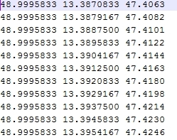
| Popis produktu | Podrobný gravimetrický kvazigeoid QGZÚ-2013 představuje transformační plochu umožňující převod nadmořských výšek H vyjádřených ve Výškovém systému baltském – po vyrovnání (Bpv) a elipsoidických výšek h určených v Evropském terestrickém referenčním systému 1989 (ETRS89) /realizace ETRF2000/ nad rotačním elipsoidem Geodetického referenčního systému 1980 (GRS80). Datový obsah tvoří výšková anomálie zeta vyjádřená v uzlových bodech pravidelné sítě (3'' x 3'') zeměpisných souřadnic ETRS89. Výšková anomálie realizuje vlastní transformační vztah, který má tvar h = H + zeta. Úplná střední chyba výškové anomálie zeta činí na území ČR 1 cm, v horském terénu a v příhraničních oblastech (do 10 km od státních hranic) může dosahovat hodnot vyšších, nejvýše však 3 cm. Model kvazigeoidu byl získán kombinovaným regionálním řešením lineární gravimetrické okrajové úlohy pro poruchový gravitační potenciál zemského tělesa, a to za významného přispění revidovaného kompletního souboru podrobných bodů gravimetrických mapování ČR zaměřených při geofyzikálním průzkumu mezi lety 1950 až 2010 a dalších dat. Model najde uplatnění zejména ve speciálních geodetických aplikacích, při kterých je v dané lokalitě vyžadována detailní znalost průběhu výškové anomálie. V těchto aplikacích model usnadní výpočet místních transformačních parametrů potřebných pro vzájemné ztotožnění výšek v referenčních systémech Bpv a ETRS89 v dané lokalitě. Upozorňujeme, že vzhledem k různému postupu zpracování se mohou výsledky transformace souřadnic mezi referenčními systémy Bpv a ETRS89 za užití tohoto modelu v dané lokalitě lišit od výsledků transformace provedené s využitím transformační služby resp. aplikace Transformace souřadnic Geoportálu ČÚZK. Pro zaručení jednotného postupu transformací a dosažení homogenity výsledků je tak potřeba použít uvedené aplikace, případně zpracovatelské programy schválené ČÚZK. | |
| Aktualizační cyklus - stav aktualizace | Podrobný gravimetrický kvazigeoid ZÚ je Zeměměřickým úřadem od roku 2013 etapově aktualizován v návaznosti na aktualizaci a zpřesňování metodiky a technologie výpočtů, aktualizaci a verifikaci dat báze podrobných gravimetrických mapování České republiky, Základní báze geografických dat České republiky a dalších datových zdrojů. | |
| Podmínky přístupu a použití | Bez poplatků Licence Creative Commons CC BY 4.0 Dle Vyhlášky č. 31/1995 Sb. | |
| Prohlížení dat | ||
| Stahování dat |
Služba Atom | |
| Kontakt - informace o produktu | Zeměměřický úřad, e-mail: ZU-obchod@cuzk.gov.cz | |

Poslední aktualizace produktu:
2014-01-01
2014-01-01
Poslední aktualizace/revize informací:
2025-03-06
2025-03-06


 RSS 2.0 Geoportál ČÚZK