

ZABAGED® - Výškopis - DMP 1G. Digitální model povrchu České republiky 1. generace v S-JTSK, Bpv
| Informace o produktu | ||
|---|---|---|
 | Název | ZABAGED® - Výškopis - DMP 1G. Digitální model povrchu České republiky 1. generace v S-JTSK, Bpv |
| Obchodní kód | 64112 | |
| Výdejní jednotka | mapový list SM5 | |
| Cena za jednotku | Bez poplatků | |
| Výdejní formáty | LAZ | |
| Souřadnicové systémy | S-JTSK / Krovak East North, Výškový systém baltský - po vyrovnání | |
| Distribuce | 


| |
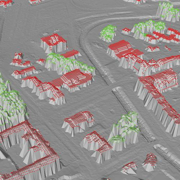
| Popis produktu | Digitální model povrchu České republiky 1. generace (DMP 1G) představuje zobrazení území včetně staveb a rostlinného pokryvu ve formě nepravidelné sítě výškových bodů (TIN) s úplnou střední chybou výšky 0,4 m pro přesně vymezené objekty (budovy) a 0,7 m pro objekty přesně neohraničené (lesy a další prvky rostlinného pokryvu). Model vznikl z dat pořízených metodou leteckého laserového skenování výškopisu území České republiky v letech 2009 až 2013. DMP 1G je určen k analýzám výškových poměrů terénu (DMR 5G) a geografických objektů na něm se vyskytujících (stavby a rostlinný pokryv) regionálního a částečně i lokálního charakteru, např. při analýzách viditelnosti, modelování šíření radiových vln, modelování šíření škodlivých látek a nečistot v ovzduší, generování virtuálních pohledů na terén v leteckých simulátorech a trenažérech, apod. | |
| Aktualizační cyklus - stav aktualizace | DMP 1G se předpokládá aktualizovat metodou obrazové korelace leteckých měřických snímků a metodou leteckého laserového skenování. Technologické postupy jsou v současné době ve vývoji. Stav aktualizace | |
| Podmínky přístupu a použití | Bez poplatků Licence Creative Commons CC BY 4.0 Dle Vyhlášky č. 31/1995 Sb. | |
| Prohlížení dat |
Mapová aplikace Služba WMS | |
| Stahování dat |
Služba Atom Export výřezu dat Stažení předpřipravených souborů - výběr nad mapou | |
| Kontakt - informace o produktu | Zeměměřický úřad, e-mail: ZU-obchod@cuzk.gov.cz | |
Poslední aktualizace produktu:
2023-06-10
2023-06-10
Poslední aktualizace/revize informací:
2025-03-06
2025-03-06
 RSS 2.0 Geoportál ČÚZK